Summary
The European Space Agency (ESA) is celebrating a major milestone for its popular Earth from Space series, which has now reached 1,000 published Earth observation images from space.
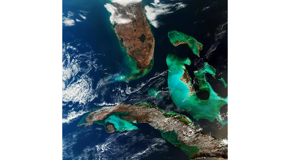
The anniversary image showcases the vibrant turquoise waters surrounding southern Florida, Cuba and the Bahamas. The image was captured in March 2026 by the Copernicus Sentinel-3 satellite from an altitude of around 800 kilometres above Earth.
The Earth from Space series has become one of ESA’s most recognizable initiatives in Earth observation, offering spectacular satellite imagery that highlights both the beauty of our planet and the environmental changes taking place across it.
The image marking the milestone
For the 1,000th publication, ESA selected a region known for its striking colours and geographical complexity. The image features southern Florida, Cuba, the Bahamas and the shallow tropical waters that create intense blue and turquoise tones.
These colours are influenced by water depth, sediments and the unique coral reef formations found throughout the area.
The importance of the Earth from Space series
The Earth from Space series was created to showcase the capabilities of European Earth observation satellites and bring the public closer to the data collected from space.
Through these images, scientists, professionals and the wider public can monitor climate change, natural disasters, ecosystem changes and human activity across the planet.
The role of Copernicus Sentinel-3
Sentinel-3 is part of the European Copernicus programme and was designed to systematically monitor Earth’s oceans, land surfaces and atmosphere. Its data support environmental research, weather forecasting, climate studies and natural resource management.
The anniversary image highlights not only the visual appeal of satellite imagery but also its scientific value in helping us better understand our planet.
What we think
Images from space remain one of the most effective ways to understand Earth’s geography and ongoing changes. The 1,000 publications of the Earth from Space series demonstrate how satellite technology can successfully combine science, education and visual storytelling.