

Summary
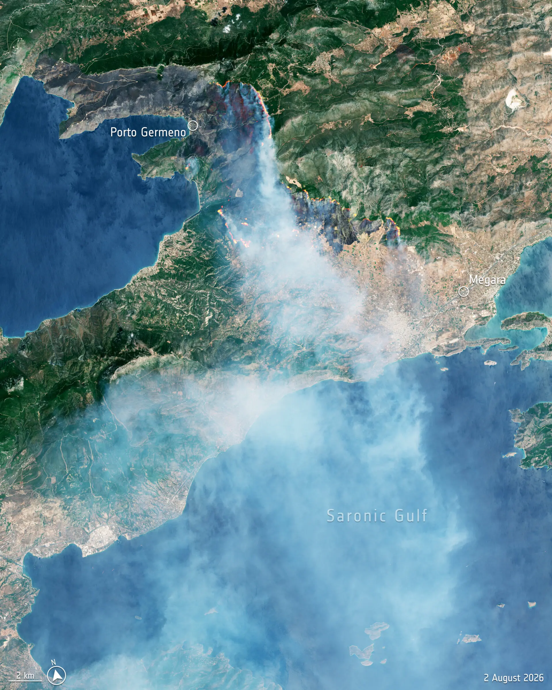
- The close-up view near Porto Germeno shows the active fire front, smoke and burned areas.
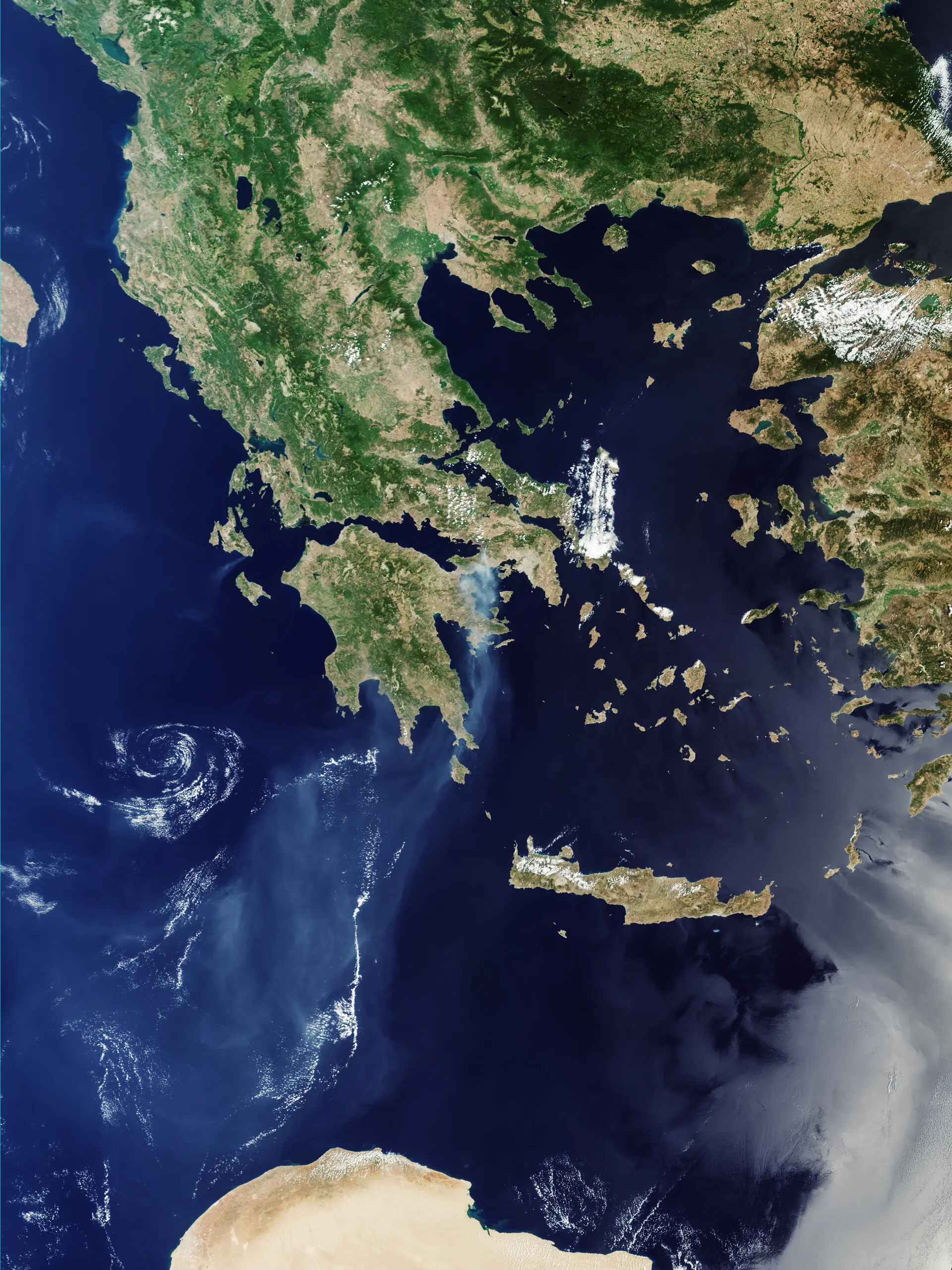
- The wider image reveals the smoke plume extending south across the Mediterranean.
- The Copernicus Emergency Management Service was activated to support authorities.
- Greece is also developing the Hellenic Fire System for satellite-based thermal monitoring of the entire country.
Two striking ESA satellite images of wildfires northwest of Athens reveal both the active fire front and burned areas, as well as a large smoke plume spreading towards the Saronic Gulf and the Mediterranean.
The European Space Agency included the images from Greece in its 2026 collection covering wildfires, drought and extreme heat. The two Greek acquisitions were captured on 2 August by Copernicus Sentinel-2 and Sentinel-3, providing two very different views of the same phenomenon: a detailed look at the fire-affected area and a much wider view of the smoke.
Their importance goes well beyond the striking view from space. Satellite observations are used to monitor the spread of fires, burned areas and smoke transport, while data from the Copernicus Emergency Management Service support civil protection authorities during real emergency situations.
The close-up image from Porto Germeno
The most detailed Greek image published by ESA comes from Copernicus Sentinel-2 and was acquired on 2 August 2026 near Porto Germeno, around 70 km northwest of Athens.
ESA processed the image by combining natural-colour bands with shortwave-infrared information, making the active fire front easier to identify at the time the satellite passed overhead.
A thick smoke plume can be seen moving southeast towards the Saronic Gulf. Burned areas appear as grey patches, particularly near the coast of the Gulf of Corinth.
The second image reveals how far the smoke travelled
On the same day, Sentinel-3 observed the region on a much larger scale. The image shows the smoke cloud from wildfires in the wider Viotia region northwest of Athens moving south and extending across a large area of the Mediterranean Sea.
The two images complement each other. Sentinel-2 provides greater detail of the active fire front and its effects on the ground, while Sentinel-3’s broader coverage reveals the regional scale of smoke transport away from the fires.
What the satellites can “see”
Sentinel-2 collects data in 13 spectral bands. In addition to imagery resembling what the human eye sees, it can use infrared information to study vegetation and areas associated with intense thermal activity.
Sentinel-3 has a different role and provides wide-area coverage. Its OLCI instrument observes a swath 1,270 km wide, while the SLSTR instrument measures land and sea surface temperatures. This combination is particularly useful when an event needs to be observed on a regional scale.
ESA also highlights Sentinel-5P, which monitors trace gases and aerosols emitted in large quantities by wildfires, as well as EarthCARE, whose instruments can identify active fires and smoke plumes and help characterise their emissions.
More than 30 CEMS activations since May
Since 1 May 2026, the Copernicus Emergency Management Service had been activated more than 30 times to provide data and mapping for wildfires in countries including Greece, France, Italy, Spain, Portugal, Croatia and Germany.
The service was also activated for the Greek fires, using satellite observations to support civil protection authorities.
A summer of extreme heat in Europe
ESA places the Greek images within a much broader 2026 record of wildfires, drought and extreme temperatures around the world. The agency notes that high temperatures, lack of rainfall and soil moisture, together with strong winds, can create highly favourable conditions for wildfire spread, regardless of whether the initial ignition is caused by human activity or natural causes.
According to the Copernicus Climate Change Service, June 2026 was the second-warmest June globally in the ERA5 dataset, while western Europe recorded its warmest June in that dataset.
Greece is also gaining its own eyes on wildfires from space
The European Sentinel imagery is particularly relevant as Greece is also developing its own national satellite-based wildfire monitoring capability. The Hellenic Fire System consists of four CubeSats, each carrying two infrared imagers designed to detect active fires, thermal anomalies and fire radiative intensity.
The system returned its first thermal image over Greece after around two weeks of instrument calibration. Once fully operational, it is designed to scan the entire country twice a day, supporting rapid wildfire detection and emergency response.
What we think
The images from Porto Germeno and the wider region northwest of Athens clearly demonstrate why satellite Earth observation now has practical value in wildfire response. These are not simply dramatic photographs taken from hundreds of kilometres above Earth: different sensors can record active fire fronts, burned areas, thermal activity and smoke transport, providing information that complements observations made on the ground.
Frequently asked questions
When were the satellite images of Greece captured?
Both images published by ESA, from Sentinel-2 and Sentinel-3, were acquired on 2 August 2026.
What does the Sentinel-2 image show?
It shows the wildfires near Porto Germeno, the active fire front, thick smoke moving towards the Saronic Gulf and burned areas near the Gulf of Corinth.
What does the Sentinel-3 image add?
The wider view reveals the scale of the smoke plume, which moved south and extended across a large area of the Mediterranean.
How do these data help during a wildfire?
Satellite observations are used to monitor the spread of fires and smoke, while the Copernicus Emergency Management Service provides mapping data to support relevant authorities.