

Summary
- ESA has released two satellite images of Mongolia and the Amazon Delta.
- Sentinel-2 uses false colours to reveal lakes and vegetation.
- Sentinel-1 combines three radar observations from 2026 to highlight changes across the Amazon Delta.
- The images demonstrate how scientific imaging captures information beyond human vision.
Two images released by the European Space Agency turn Mongolia and the Amazon Delta into a striking demonstration of what satellites can reveal beyond conventional photography.
Published on 6 and 13 November 2026, the two views use very different methods: multispectral measurements from Sentinel-2 and a radar-data composite from Sentinel-1. Their vivid colours are not merely a visual effect. They encode information our eyes cannot directly perceive.
Mongolia: three lakes in an extraordinary landscape
Captured on 11 April 2026 over Khovd Province in western Mongolia, the Sentinel-2 image shows Lake Khar-Us on the left, Khar on the right and Durgun further south, linked to Khar. The lakes are part of the Great Lakes Depression, a region with remnants of a prehistoric lake and important ecosystems amid the arid steppe.
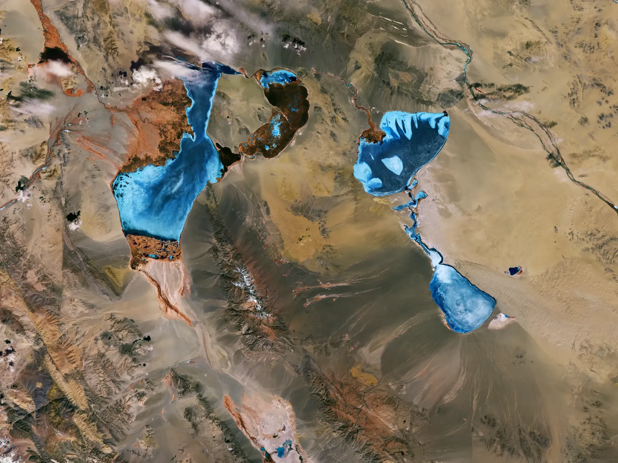
Near Khar-Us stands the snow-covered Jargalant Hayrhan mountain, reaching 3,796 metres. South of the lake is Takhiltiin Khotgor, an archaeological site within the UNESCO-listed Cemetery Complexes of the Xiongnu Nobility.
Sentinel-2 measures light across visible, near-infrared and shortwave-infrared wavelengths. ESA combines selected bands into a false-colour image: reddish tones indicate vegetation, lighter blue indicates more turbid water, and darker blue or black suggests deeper, clearer water. These are not the natural colours a regular camera would capture.
Amazon Delta: three dates in a single image
In northern Brazil, near the equatorial city of Macapá, ESA used Sentinel-1 radar data to highlight changes in the Amazon Delta. The composite combines acquisitions from 15 August, 20 September and 26 October 2026.
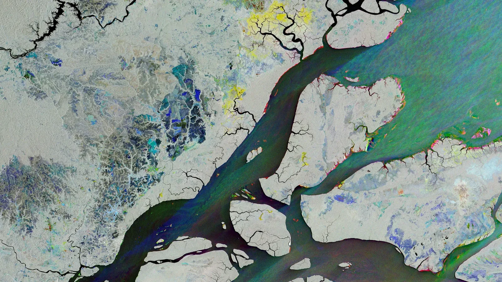
Blue marks changes detected in the 15 August acquisition, green those observed on 20 September, and red differences recorded on 26 October. Areas that remained relatively stable appear grey, white or black. Bright patterns along riverbanks and the coast may be associated with vegetation, water conditions or shifting banks. The colours reveal when differences were detected, not necessarily what caused them.
Macapá appears towards the lower left as a largely stable grey area. A blue network north of the city may reflect vegetation changes, while red edges along riverbanks indicate surface differences detected in October. Even boats on the river appear as tiny coloured marks.
Why the images look so different
Sentinel-2 works more like a conventional camera, measuring sunlight reflected by the surface in multiple spectral bands. Sentinel-1 instead sends out microwave pulses and records their return using synthetic aperture radar (SAR). That allows it to observe Earth at night and through cloud cover that would obstruct optical imagery.
The distinction matters in real-world applications. Satellite observations of wildfires in Greece demonstrate the value of optical Sentinel imagery, while Sentinel-1 tracking of a Greenland glacier breakup shows how radar can help detect changes at Earth’s surface.
What we think
These images are a useful reminder that photography and scientific imaging may start with a similar idea, but do not always share the same goal. Look at Mongolia as a photograph and you see a stunning arrangement of lakes and mountains. Learn how the colours are mapped, and the same picture begins to tell you about vegetation and the different characteristics of the water.
The Amazon image is especially interesting for anyone who works with visual storytelling: it combines three moments in time into one frame. A red line along a riverbank may tell us something changed in October, but not precisely why it happened. Understanding that distinction makes the image more informative and more trustworthy.
For photographers and visual creators, it is worth learning to read these images rather than simply admire them. Composition, colour mapping and data selection shape the story being told — just as our own choices do behind the camera.
Frequently asked questions
Are these the real colours of the landscapes?
Not in the sense of a conventional photograph. The Mongolia image uses false colours to visualise multispectral information, while the Amazon image maps radar observations from different dates to different colours.
Can Sentinel-1 collect imagery without sunlight?
Yes. Sentinel-1 radar transmits its own microwave signal, allowing it to gather data by day or night, even when the area is covered by clouds.