

Summary
- NASA published two Landsat 8 images of Cyprus on November 5, 2026.
- The Akrotiri Peninsula formed as two natural land bridges connected older landmasses.
- The salt lake supports wintering flamingos, but NASA cites evidence of a sharp recent decline.
- The Troodos Mountains preserve rocks formed in an ancient ocean.
NASA’s new satellite images of Cyprus reveal how the Akrotiri Peninsula formed, why its salt lake changes with the seasons, and what is happening to the flamingos that depend on the wetland.
On November 5, 2026, NASA Earth Observatory published two views acquired on October 10 by Landsat 8’s OLI (Operational Land Imager). One shows western Cyprus and the Troodos Mountains; the other focuses on the Akrotiri Peninsula, Limassol, and the salt lake.
A peninsula that was once a separate island
The geography of Akrotiri has a surprising history. According to NASA, a smaller island once lay to the south of ancient Cyprus. Sediments carried by rivers and the sea gradually filled the channel between them, creating two natural bridges of sand and gravel known as tombolos. These connected the two landmasses and formed today’s peninsula.
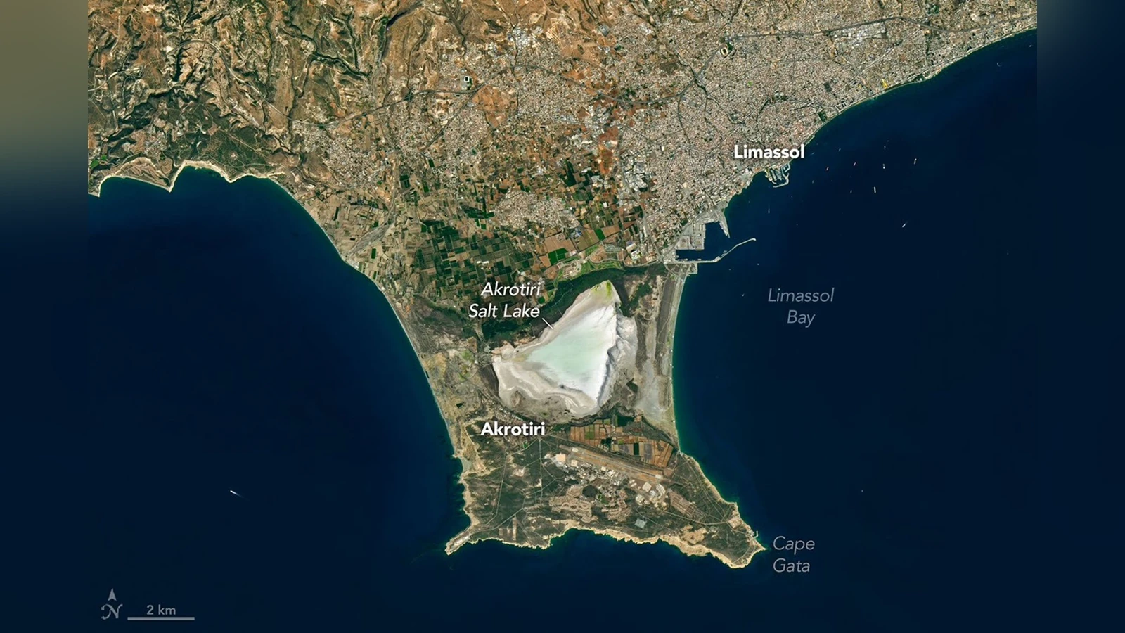
The western tombolo, associated with the Kouris River, began forming roughly 50,000 years ago. The eastern strip of land completed the separation from the Mediterranean much later, within the past 2,000 years. Akrotiri Salt Lake, a coastal lagoon that was once connected to the open sea, remained between the two land bridges.
A seasonal salt lake and its flamingos
When the October 10 image was captured, seasonal rains had already started to refill the lake. Water levels fluctuate significantly during the year: the lake typically fills in late autumn and winter, while large areas dry out in summer. This natural cycle shapes the surrounding wetland habitat.
Flamingos have traditionally spent the winter at Akrotiri. Their diet includes tiny crustaceans rich in carotenoids, pigments that contribute to their distinctive pink feathers. NASA says the winter population historically averaged about 4,000 birds, but cites news reports recording just 30 in 2025. That is a dramatic decline, although this satellite image alone cannot establish its causes.
The Troodos Mountains preserve a piece of an ancient ocean
In the wider satellite view, the Troodos Mountains appear as a broad, dark-green area. Beneath the vegetation lie rocks that tell a much older story: about 90 million years ago, molten material solidified on the seafloor, forming new oceanic crust. Tectonic forces later lifted some of those rocks above sea level. Today they are known as ophiolites.
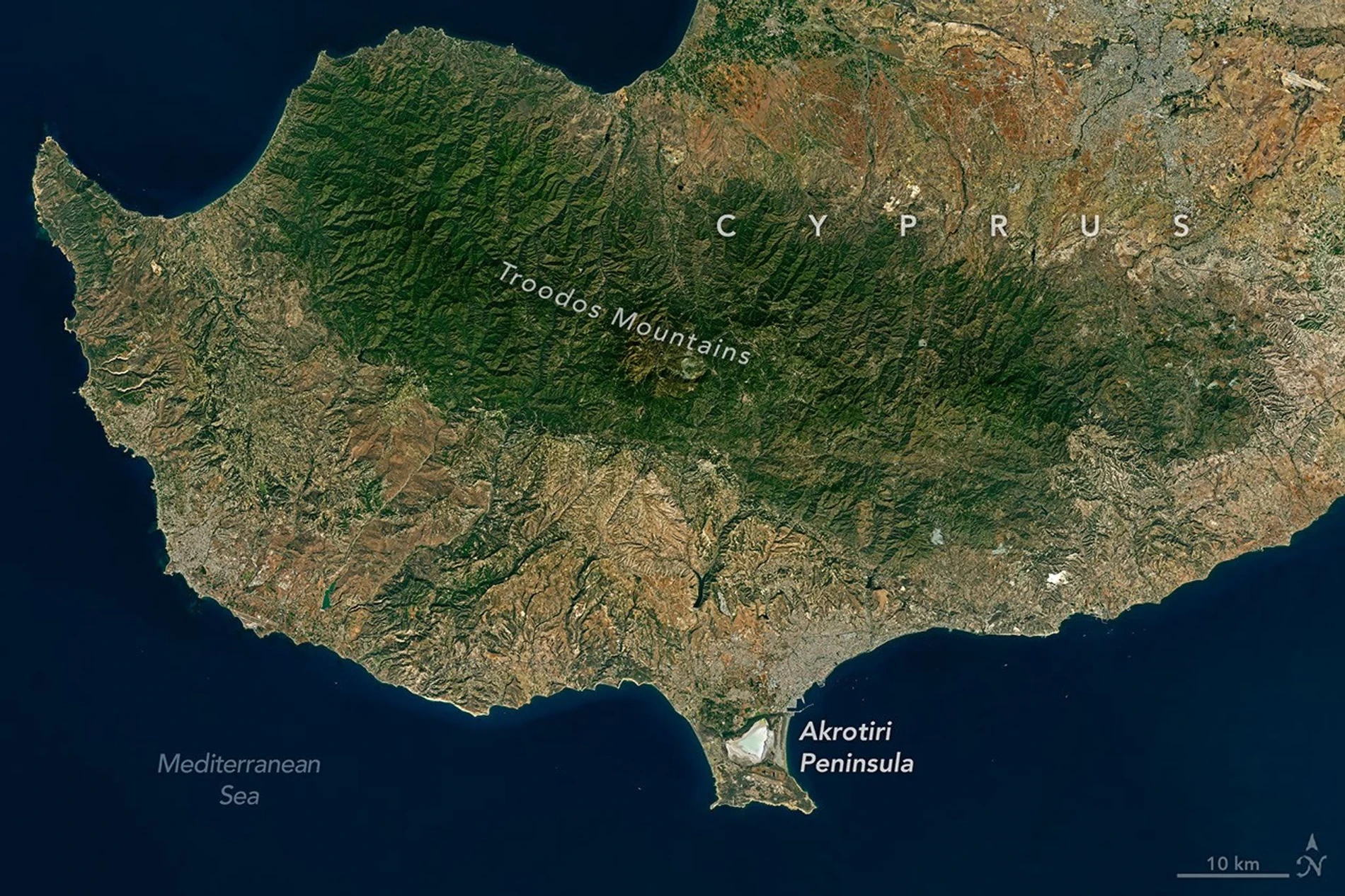
Cyprus is remarkable because an aerial view reveals the surface of a landscape partly built from rocks that once formed deep beneath the sea. Landsat, a joint NASA–USGS programme, has built a decades-long record of Earth observations. Its imagery also has creative uses — such as NASA’s tool that turns Landsat landscapes into letters — but its greatest strength is allowing us to compare the same place across different dates.
From Ophiousa to Cape Gata
NASA also highlights a local legend. In antiquity, Cyprus was known as “Ophiousa,” a name associated with snakes. According to tradition, Helena, mother of Constantine the Great, sent cats from Egypt in the fourth century to help control the snakes. The story is associated with Cape Gata and the Holy Monastery of St Nicholas of the Cats. This is folklore, not something satellite imagery could verify.
What we think
If you photograph landscapes or wildlife, these are the kind of satellite images worth studying rather than scrolling past. One frame brings together geological history and an ecosystem that changes with the seasons. The two narrow land bridges explain why the salt lake sits exactly where it does.
The flamingo figures are what stay with us, though. A striking satellite image cannot count a species’ population on its own or explain a decline. What it can do is give us the wider picture: changing water levels, human activity around the wetland, and the value of tracking the same environment year after year.
That combination of visual storytelling and evidence matters far more than a beautiful social-media image. It encourages us to revisit places, compare seasons, and see nature as something constantly changing rather than a fixed backdrop.