


Summary
- NOAA-20 captured Cyclone Arnab at night on October 26.
- Its VIIRS sensor revealed the storm’s spiral structure beside the lights of Indian cities.
- Winds were around 140 km/h at the time of the observation.
- The cyclone made landfall in India on October 28 with winds of about 130 km/h.
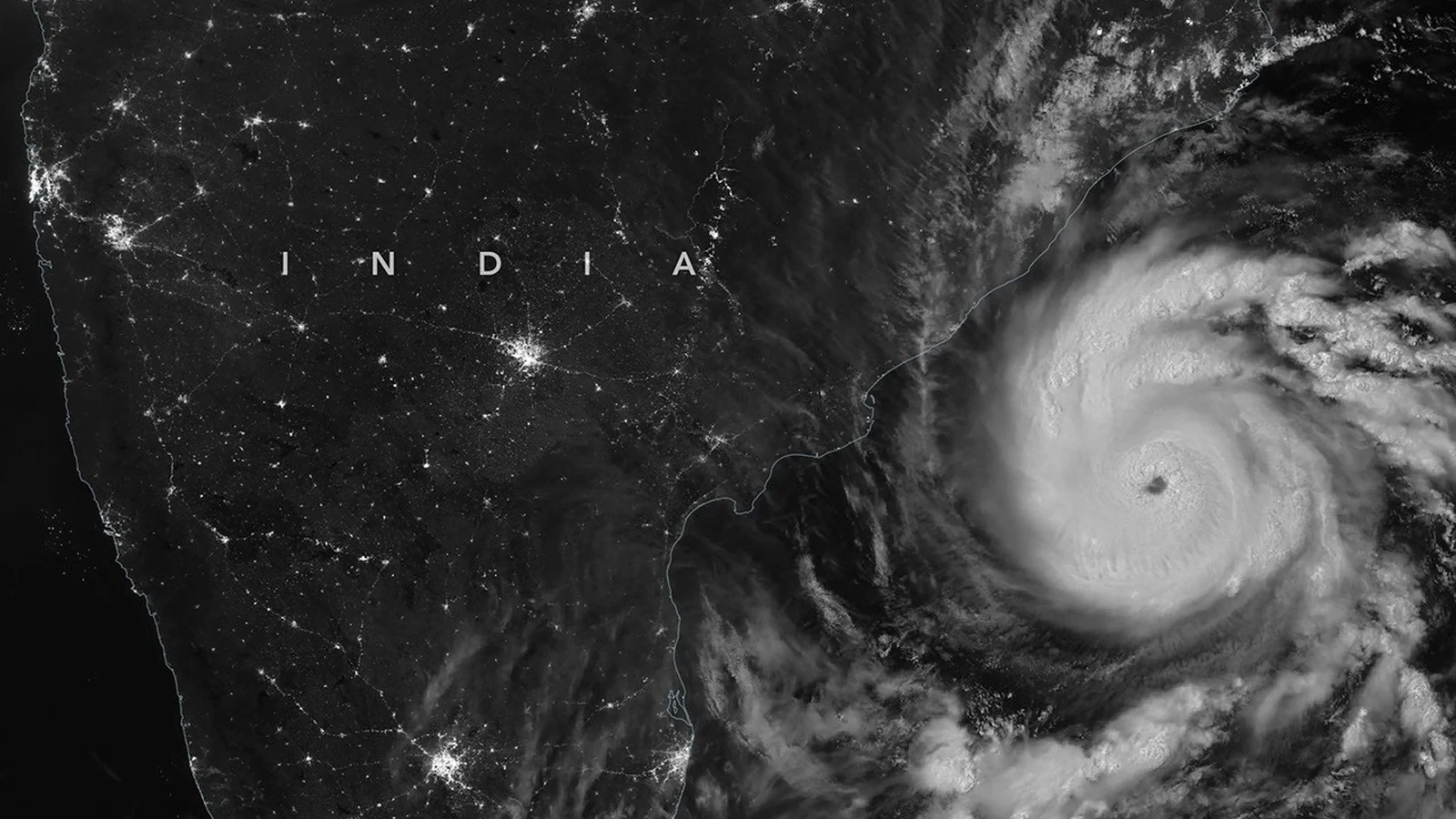
A huge swirl of clouds over the Bay of Bengal, with the lights of India glowing beside it in the dark: NASA’s latest nighttime satellite image captures Cyclone Arnab shortly before it reached land.
NASA Earth Observatory published the image on October 29, 2026, three days after the satellite observation and one day after the cyclone reached India’s eastern coast.
A clearly defined eye in the darkness
On the right, the massive spiral cloud system and the cyclone’s eye dominate the frame. To the left, the land is dark, but illuminated cities and road networks form a dense scatter of bright points. The contrast reveals both the storm’s structure and its proximity to populated areas.
The observation was made on October 26 at 20:12 UTC, or 1:42 a.m. on October 27 in India. At that time, sustained winds reached approximately 140 km/h, according to the India Meteorological Department (IMD).
How a satellite sees clouds at night
The image was captured by the VIIRS (Visible Infrared Imaging Radiometer Suite) instrument aboard NOAA-20. Its highly sensitive low-light channel, known as the day-night band, can detect faint sources of light on Earth and, under suitable conditions, moonlight reflected from cloud tops.
This is not a conventional photograph made in a single exposure. The instrument scans the scene, and its measurements are processed into a satellite image. Similar nighttime observations also help scientists study changes in artificial lighting across Earth, as illustrated by NASA’s Black Marble maps.
Landfall and the damage on the ground
Arnab formed over the Bay of Bengal on October 25, becoming the first named storm of the 2026 North Indian Ocean cyclone season. That was a late start for a basin where named cyclones typically begin appearing in April or May.
Early on October 28, the cyclone made landfall along the Andhra Pradesh and Yanam coast, between Bapatla and Visakhapatnam, with sustained winds of around 130 km/h. The IMD classified it as a very severe cyclonic storm.
The storm uprooted trees, flooded crops and homes, and disrupted transport and electricity networks. Authorities had evacuated tens of thousands of people from vulnerable coastal areas before landfall, according to NASA.
What we think
What makes this image so striking is its ability to show both the scale of the cyclone and the cities nearby in a single frame. Your eye goes straight to the storm’s center, but it is the tiny lights on land that bring the human stakes into focus.
For photographers and visual storytellers, the capture method is just as compelling. Very little light becomes valuable scientific data. It is a reminder that imaging can do more than produce dramatic pictures: it can help us understand a dangerous event as it unfolds.
Frequently asked questions
Was the image taken with a conventional camera?
No. It was created using measurements from the VIIRS instrument aboard NOAA-20, which scans Earth and records extremely low levels of light.
How can clouds be visible when the image was taken at night?
The VIIRS day-night band can detect faint visible light, including moonlight reflected from clouds, as well as artificial light sources. Bright-looking clouds do not mean the observation was made in daylight.