

Summary
- Sentinel‑1 captured the loss of 76 square kilometres from Petermann Glacier.
- The new iceberg is comparable in area to Manhattan and may be up to 150 metres thick.
- It is Petermann’s largest loss of floating ice since 2012.
- Two additional large sections are being monitored as fractures continue to develop.
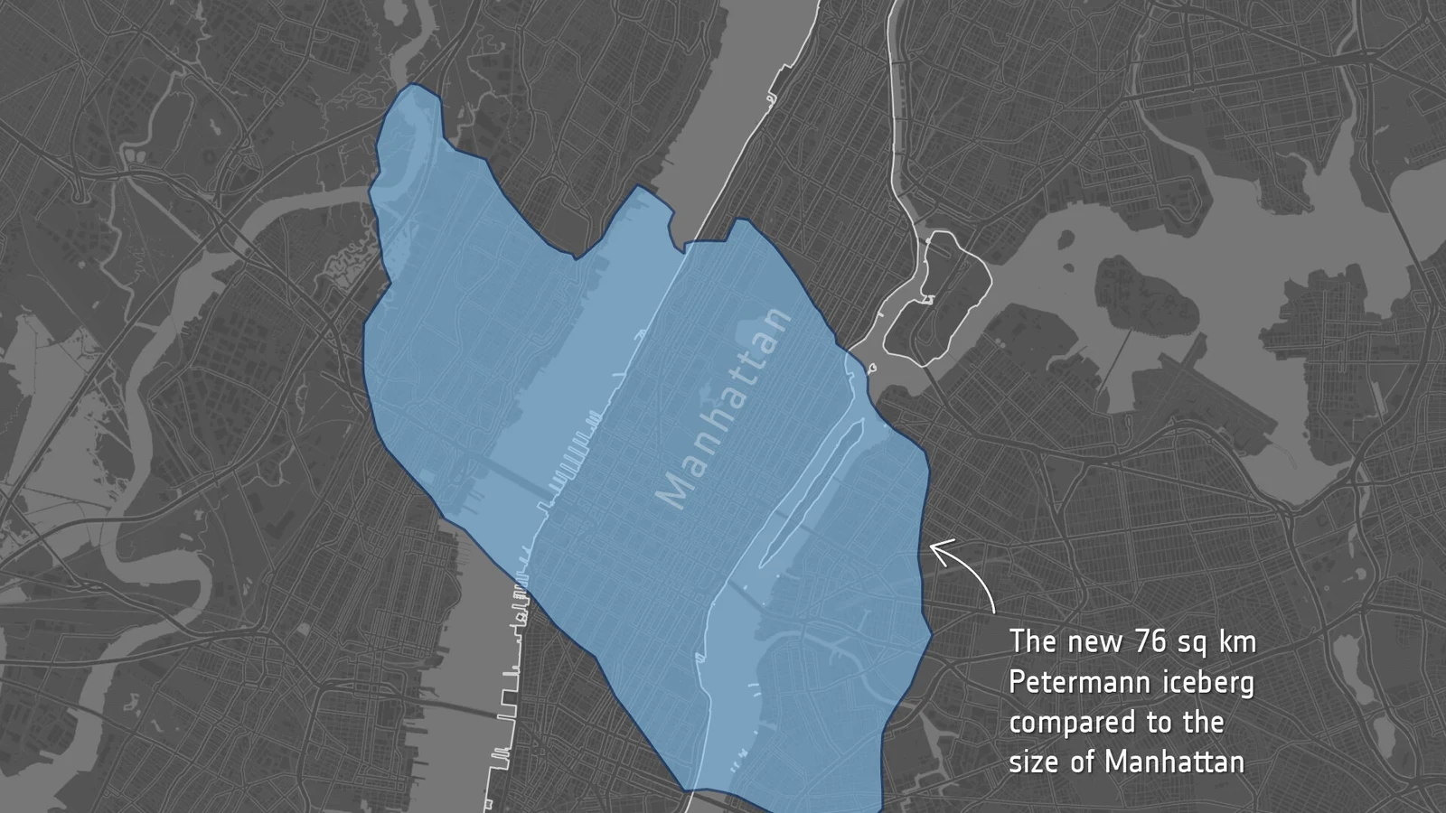
Copernicus Sentinel‑1 has captured the loss of 76 square kilometres from Petermann Glacier’s floating ice tongue in Greenland, creating an ice island with an area comparable to Manhattan.
The enormous mass broke away from the glacier’s eastern side in northwest Greenland on August 4, 2026. According to the European Space Agency, the new iceberg may be up to 150 metres thick and represents Petermann’s largest loss of floating ice since 2012.
The event matters for more than its size. Satellite imagery allowed scientists to follow the growth of fractures before the calving, document the change almost in real time and identify two more large sections that may break away in the future.
What Sentinel‑1 captured
A radar image acquired on August 3 showed pronounced deterioration along the centreline of the floating tongue. By the following day, the large tabular iceberg had detached from the eastern side. Its relatively flat form is typical of large sections calved from floating glacier tongues.
The 76-square-kilometre loss is also the most significant Arctic calving event recorded since 2020. The comparison with Manhattan conveys its surface area, while the estimated thickness of up to 150 metres reveals the true three-dimensional scale of the mass.
Why radar sees through cloud
Sentinel‑1 satellites use synthetic-aperture radar and do not depend on sunlight. They can observe the surface day and night and collect data through cloud cover, a particularly useful capability in remote polar regions where optical imagery is often limited by weather.
In this case, Sentinel‑1C and Sentinel‑1D made observations one day apart during Sentinel‑1D’s commissioning phase. Interferometric comparison revealed deformation, surface movement with ocean tides and the rapid propagation of fractures before the final break.
The fractures had been monitored for years
An international team from the University of Ottawa, the Universities of Stirling, Lancaster and Leeds, and the Canadian Ice Service has monitored Petermann since 2019 with support from ESA’s ARCTEX project. Researchers had documented gradual fracture growth and increasing signs of instability in the ice tongue.
Interferometric observations from April 2026 had already shown deformation inside the ice. The calving therefore did not occur without warning; it was the final stage of a process monitored for months and, on a broader scale, for years.
Petermann’s history of major calving
Petermann is one of Greenland’s largest glaciers still retaining an extensive floating ice tongue. Major events formed ice islands in 2008, 2010 and 2012. After 2012, the tongue remained relatively stable despite several smaller calving events.
That period of relative stability ended on August 4. Scientists have identified two additional sections, approximately 97 and 87 square kilometres, that could detach as existing rifts continue to propagate. No specific timing has been given for their possible calving.
What it means for sea level
The section was already floating, so its transformation into an iceberg does not by itself cause a corresponding immediate rise in sea level. The scientific importance lies in longer-term dynamics: floating tongues can provide resistance to ice flowing from land.
If retreat changes the speed at which grounded ice moves toward the ocean, the effects may influence the glacier’s future contribution to sea-level rise. This is why continuous monitoring is necessary rather than a conclusion based on one event.
Risks to navigation
Environment and Climate Change Canada is tracking the iceberg and assessing possible risks to shipping routes and infrastructure. Ice masses of this scale can remain in the ocean for years and gradually break into smaller fragments that become harder to detect and monitor.
What we think
The story’s value goes beyond the Manhattan comparison. Most important is that researchers followed the event from fracture growth to iceberg formation, demonstrating the power of systematic satellite observation. Accuracy is also essential: a floating section does not automatically translate into an equivalent rise in sea level, but it is a critical part of the glacier’s wider dynamics.
Frequently asked questions
How large is the new iceberg?
It covers approximately 76 square kilometres and is estimated to be up to 150 metres thick.
When did it break away?
The final separation was recorded on August 4, 2026.
Does it immediately raise sea level?
The section was already floating, so the immediate effect does not correspond to its total volume. Loss of the tongue may nevertheless affect future grounded-ice flow.
Could more sections break away?
Two additional areas of approximately 97 and 87 square kilometres are being monitored as their fractures continue to develop.