

Summary
- ESA released a virtual flight around Mars’ Schiaparelli Crater on August 19, 2026.
- The 4-minute, 10-second video was created from HRSC data and a digital terrain model rather than footage from an actual camera flight.
- The crater is roughly 450-460 kilometres wide but relatively shallow, likely because lava and deposits carried by water and wind gradually filled it.
- The visualisation uses threefold vertical exaggeration and renders 50 frames for every second of video.
- The route passes ancient valleys, volcanic features and the Brazos Valles network.
- This is not footage from a real flight over Mars
- The route reveals ancient valleys and volcanic traces
- How a 450-460 km crater became so shallow
- The camera that turns Mars into a 3D landscape
- A 2003 mission that is still operating
- From the “canali” of 1877 to The Martian
- What we think
- Frequently asked questions
ESA takes us on a spectacular virtual flight around Mars’ enormous Schiaparelli Crater, revealing how water, wind and volcanic activity dramatically reshaped the landscape over billions of years.
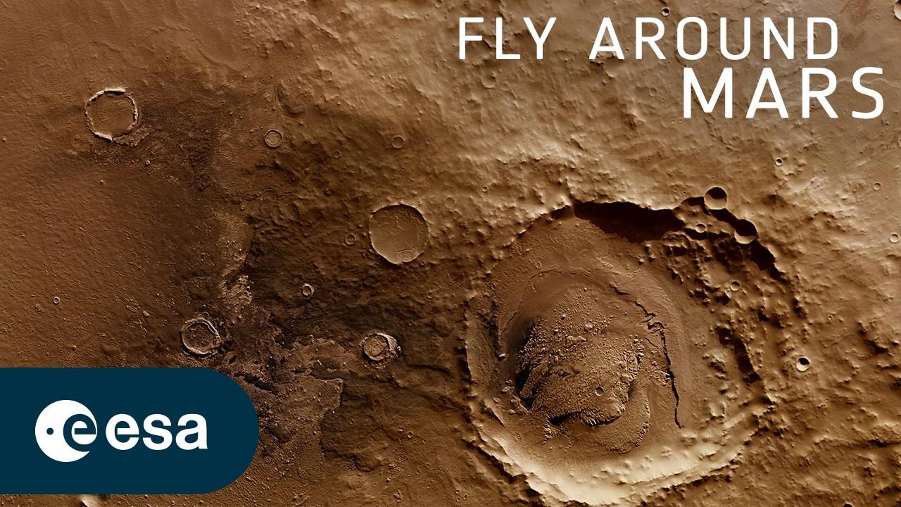
On August 19, 2026, the European Space Agency released a 4-minute, 10-second video offering a virtual tour around one of the largest impact craters on Mars. The flight was created from real data collected by Mars Express’ High Resolution Stereo Camera, HRSC, combined with a digital terrain model of the Martian surface.
The importance of the video goes beyond its visual impact. Schiaparelli measures roughly 450-460 kilometres across but is unusually shallow for a crater of its size, with its present-day relief reaching only around 2-2.5 kilometres. The data indicate that the original crater was gradually filled by lava and material transported or deposited by water and wind.
This is not footage from a real flight over Mars
The video may look like footage captured by a spacecraft flying low above the surface, but it is actually a three-dimensional reconstruction. Its foundation is the Mars Chart HMC-30 dataset, a mosaic assembled from multiple HRSC observations and combined with elevation information from a digital terrain model. The scene is centred at roughly 8° south and 17° east.
For every second of the final video, 50 individual frames were rendered along a predefined virtual camera path. A threefold vertical exaggeration was also applied to make changes in topography easier to perceive. Clouds and atmospheric haze were added for the visualisation and to conceal the limits of the terrain model, with the haze beginning to build at a distance of around 250 kilometres.
This distinction matters when interpreting the imagery: the landscape is based on real measurements, but the camera motion, atmospheric effects and enhanced sense of elevation are elements of the visualisation rather than footage of an actual flight.
The route reveals ancient valleys and volcanic traces
The virtual flight begins south of the crater near Evros Vallis, a branching valley system more than three billion years old. It then heads north, crosses a complex of unnamed craters and approaches an extensive network of ancient valleys south of Schiaparelli.
The route crosses the western rim and turns clockwise to reveal the crater’s interior. Smaller craters and distinctive “wrinkle ridges” are visible on the floor, elongated features associated with volcanic plains and crustal deformation. DLR notes that these structures provide evidence that lava once covered parts of the crater.
A large dark belt of sand, most likely volcanic in origin, can also be seen near the southern part of the crater, where winds have accumulated the material. The flight concludes with a steep climb over Brazos Valles, a valley network extending for almost 400 kilometres along Schiaparelli’s southern rim.
How a 450-460 km crater became so shallow
Schiaparelli’s depth raises one of the most interesting geological questions. According to DLR, an object roughly 30-40 kilometres across may have produced the original impact. A basin on this scale could initially have been around four to five kilometres deep or more, rather than displaying the much smaller relief seen today.
The leading explanation is that its interior gradually filled over the past three to four billion years. Lava, sediments transported by ancient water and material carried by Martian winds all appear to have contributed. Smaller craters inside the basin are themselves filled almost to their rims, while the main crater rim has been heavily eroded.
ESA had already presented evidence in 2010 that water was once present in this region, possibly even in the form of a lake. Sedimentary formations on the floor were found to resemble deposits left behind when lakes evaporate on Earth.
The camera that turns Mars into a 3D landscape
HRSC was developed by the German Aerospace Center and has been operating aboard Mars Express since science observations began in 2004. It uses multiple sensor lines to observe the surface from different angles, allowing stereo information to be extracted and digital elevation models to be created.
Under suitable observing conditions, the main camera can achieve a resolution of roughly 10 metres per pixel, while its Super Resolution Channel can reach around 2.3 metres per pixel in selected areas. These figures describe the capabilities of the imaging system and do not necessarily represent the resolution of every part of the mosaic used for this new video.
The same technology has produced many of Mars Express’ remarkable planetary maps. PTTL previously covered the large Mars panorama released by ESA to mark 20 years of Mars Express, which was also assembled using HRSC data.
A 2003 mission that is still operating
Mars Express launched on June 2, 2003 and successfully entered orbit around Mars on December 25 of the same year. It was Europe’s first mission to the Red Planet and, as of August 2026, ESA continues to list the spacecraft as operational.
Its observations extend well beyond photography. Mars Express instruments study the planet’s geology, minerals, atmosphere and subsurface, and the mission has played a major role in investigating the history of water on Mars.
From the “canali” of 1877 to The Martian
The crater is named after Italian astronomer Giovanni Schiaparelli, who mapped Mars during the Great Opposition of 1877. In his observations he described dark linear features using the Italian word “canali”, referring to natural channels. The later interpretation of the word as artificial “canals” helped fuel the popular idea that Mars contained constructed waterways and possibly intelligent life. Later observations showed that these lines were optical illusions produced by the limited telescopes of the era.
Schiaparelli also has a place in modern popular culture: in Andy Weir’s novel “The Martian”, it is astronaut Mark Watney’s final destination.
What we think
The new visualisation is particularly interesting because it demonstrates what becomes possible when photographic imaging is combined with accurate stereo and elevation data. Behind the spectacular “flight” is not simply an animation, but more than two decades of systematic mapping of Mars. In Schiaparelli’s case, the 3D view also makes a difficult geological question easier to understand: how an enormous impact crater can be transformed so substantially over billions of years.
Frequently asked questions
Is this actual footage from a flight over Mars?
No. It is a 3D visualisation produced from real HRSC stereo imagery and a digital terrain model. The virtual camera follows a predefined route, while elevation has been exaggerated by a factor of three.
How large is Schiaparelli Crater?
ESA gives a diameter of approximately 460 kilometres, while DLR uses a figure of around 450 kilometres. In either case, it is one of the largest impact craters on Mars.
Why is it so shallow compared with its size?
The available geological evidence indicates that the crater was filled over billions of years by lava, material carried or deposited by water, and deposits transported by wind.
Is the crater the same “Schiaparelli” as the ExoMars spacecraft?
No. Schiaparelli Crater and the ExoMars Schiaparelli Entry, Descent and Landing Demonstrator Module are different things. Both were named in honour of Italian astronomer Giovanni Schiaparelli.