


Summary
- A drone captured the first stages of the Langtang Lirung collapse on 26 August 2026
- New imagery indicates that bedrock collapsed together with part of the glacier
- The USGS confirmed that the magnitude 5.2 signal came from the collapse rather than an earthquake
- The debris flow reached speeds of about 50 metres per second in parts of its path
- By 30 August at least 750 people had been reported dead and more than 3,000 missing
- The precise role of climate change in this specific collapse is still being investigated
- What the drone video shows
- It was apparently not only ice that collapsed
- The magnitude 5.2 “earthquake” was not an earthquake
- From a mountainside collapse to a flood nearly 100 kilometres long
- The death toll continues to rise
- Climate change is a risk factor, not yet a proven sole cause
- Early estimates of the collapse size remain uncertain
- Why the drone footage could matter
- What we think
- Frequently asked questions
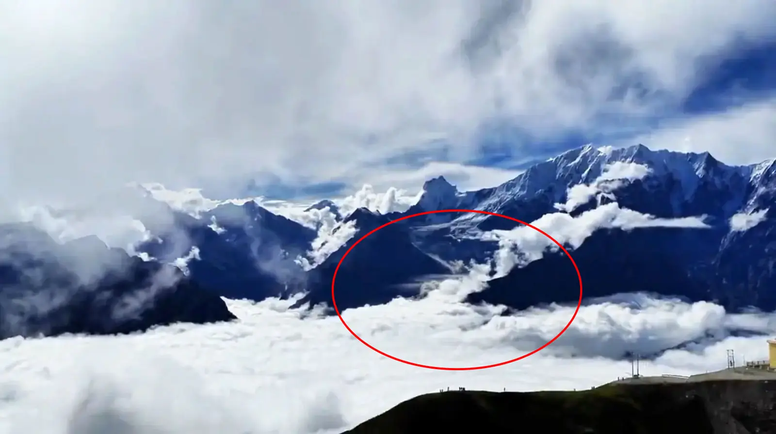
A drone flying on the Chinese side of the Himalayas appears to have captured the rock-and-ice collapse on Langtang Lirung almost as it happened, providing scientists with rare visual evidence of the sequence behind the 26 August 2026 disaster.
New footage published by Nepali Times shows a white mass beginning to descend the north face of Langtang Lirung, followed shortly afterwards by an enormous brown cloud of dust and debris rising from the Lhende Khola valley. Later drone and satellite imagery indicates that a significant section of underlying bedrock failed together with the ice.
The footage is scientifically important because it can help reconstruct an exceptionally fast natural event that evolved within minutes from a high-altitude slope collapse into a rock-and-ice avalanche, debris flow and ultimately a catastrophic flood tens of kilometres downstream. The USGS has also confirmed that a seismic signal equivalent to magnitude 5.2 was not caused by an earthquake but by the collapse and subsequent debris flow itself.
What the drone video shows
According to Nepali Times, the drone operator (Hey Mu (黑沐) / Xiaohongshu) was on the Chinese side near a mountaintop radar station, with a clear view towards the 7,234-metre Langtang Lirung and Kimshum peaks. The flight was already under way when the first white stream appeared on the mountainside, followed by the huge dust cloud lower in the valley.
The significance of the footage goes beyond its dramatic appearance. Until then, much of the scientific analysis had depended on before-and-after satellite imagery. The accidental drone recording adds a time dimension to the event, while photographs captured later allowed researchers to examine the failure zone more clearly.
It was apparently not only ice that collapsed
Early assessments focused mainly on the collapse of part of a glacier. Clearer satellite imagery from the following day, however, showed that the bedrock beneath the ice had also failed.
Geomorphologists Kristen Cook and Dan Shugar concluded from the imagery that a larger portion of the rocky mountainside had given way and carried glacier ice with it. This is an important distinction because it changes how researchers assess the mechanism that initiated the disaster.
The USGS places the source of the event on a glaciated mountain cliff on the north side of Langtang Lirung inside Langtang National Park. The agency says the resulting debris flow and flooding affected areas almost 100 kilometres downstream.
The magnitude 5.2 “earthquake” was not an earthquake
One of the most important findings concerns the strong seismic signal recorded on 26 August. It was initially reported as a magnitude 4.4 earthquake.
After analysing long-period seismic waves and satellite data, the USGS revised that interpretation: no earthquake had occurred. The signal was generated by the enormous movement of rock, ice and debris and carried energy equivalent to a magnitude 5.2 event.
The distinction is important because it currently rules out the scenario in which an earthquake triggered the initial collapse.
From a mountainside collapse to a flood nearly 100 kilometres long
After the mass struck the valley floor, rock, ice, mud and water continued through the steep, narrow terrain at extreme speed.
Chinese government geologist Guo Zhaocheng estimated that the flow reached about 50 metres per second, roughly 180 km/h, along part of its route and travelled for more than 20 kilometres before the disaster continued through the river system.
Gyirong Port on the Tibet-Nepal border was struck by the flow, after which flooding propagated through the Lhende Khola, Bhote Koshi and Trishuli systems. ICIMOD reported a sudden surge of water, sediment and boulders through the river network, causing widespread destruction.
The death toll continues to rise
Figures remain fluid as search and rescue operations continue. By the morning of 30 August, authorities had reported at least 750 deaths across both sides of the border and more than 3,000 people missing.
Nepal had confirmed 734 deaths and 2,498 missing people, while authorities in China’s Gyirong County reported 16 deaths and 546 missing. More than 90,000 people are estimated to have been affected.
Nepal’s Ministry of Home Affairs confirms that the catastrophic flood struck Rasuwa district on the morning of 26 August and affected riverbank areas across Rasuwa, Nuwakot, Dhading and Gorkha.
Climate change is a risk factor, not yet a proven sole cause
Glacier retreat and thawing permafrost can reduce the stability of high mountain slopes because frozen material can act as a binding element within fractured rock and soil.
However, scientists stress that there is not yet sufficient evidence to attribute this particular collapse solely to climate change. Cook and Shugar note that landslides also occur for natural geological reasons, although a warmer climate is expected to increase some forms of instability in glaciated mountain terrain.
The distinction matters: the broader impact of warming on glaciers and permafrost is well established, but the exact chain of causes at Langtang Lirung remains under investigation.
Early estimates of the collapse size remain uncertain
Numerical estimates of the volume or mass involved have not yet stabilised.
An analysis published by the European Geosciences Union’s Hydrological Sciences Division on 28 August gave a preliminary order-of-magnitude estimate of roughly 0.5 to 10 million cubic metres for the initial mass movement, while stressing that the amount of additional material entrained downstream had not yet been calculated.
That means much larger figures appearing in early media reports should not yet be treated as definitive scientific measurements.
Why the drone footage could matter
The event illustrates another role for drones beyond filmmaking and mapping: they can become valuable sensors during natural disasters, particularly when they happen to be airborne as an event begins.
Combined with satellites, seismometers, ground stations and subsequent drone flights, such material can help researchers determine which part of a slope failed first, the direction of movement and the speed at which the sequence developed.
This does not mean drones can currently predict such collapses. It does, however, demonstrate the potential value of continuous monitoring in areas where glaciers, steep slopes, permafrost and inhabited valleys coexist.
What we think
The footage is more important as a scientific record than as a spectacular video of a disaster. Combined with USGS data and satellite imagery, it strengthens the assessment that the Langtang Lirung event involved the failure of a complex rock-and-glacier system rather than simply a block of ice.
At the same time, the speed with which the initial collapse turned into a disaster tens of kilometres away highlights the challenge of early warning in the Himalayas. The next critical step is not to rush to a single-cause explanation, but to combine the new evidence to improve monitoring of similarly hazardous mountain slopes.
Frequently asked questions
What did the drone capture in Nepal?
The drone appears to have captured the first stages of the collapse on the north side of Langtang Lirung, as a white mass descended the slope and a large dust cloud subsequently rose from the valley.
Did an earthquake cause the collapse?
Available USGS evidence indicates that it did not. The seismic signal initially interpreted as an earthquake was later attributed to the collapse and debris flow itself.
Did only a glacier collapse?
Newer satellite imagery indicates that part of the underlying bedrock also failed, carrying glacier ice with it.
How fast did the flow move?
Along part of its path, the flow has been estimated at about 50 metres per second, or roughly 180 km/h.
Was climate change the cause?
Warming and permafrost thaw are considered factors that can increase mountain instability, but scientists have not yet demonstrated that this specific collapse was caused solely by climate change.