

Summary
- The OTUS Project sends custom-built drones into active tornadoes.
- The aircraft reach 220 mph and carry cameras and scientific sensors.
- The team has recorded 19 drone penetrations across 15 tornadoes.
- The data could contribute to better warnings and more resilient buildings.
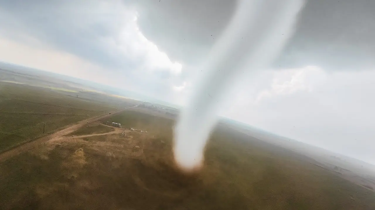
Custom-built drones are entering active tornadoes, capturing remarkable footage and scientific data that are extremely difficult to collect by any other method.
The OTUS Project team has flown directly through tornado funnels using small, extremely fast drones carrying cameras and specialized sensors. In June 2026, according to Fstoppers, the team live-streamed a drone entering an EF3 tornado for the first time.
The effort is not solely intended to produce spectacular footage. Measurements of temperature, humidity, pressure, and three-dimensional wind loads from inside a vortex could help scientists better understand tornado behavior, improve forecasting models, and strengthen building resilience.
What is the OTUS Project?
The OTUS Project, whose name stands for Observations of Tornadoes by UAV Systems, is a research effort founded by students in meteorology and engineering. The project was initially funded primarily by its members and combines unmanned aircraft technology, specialized software, and sensors developed for the extreme conditions found inside tornadoes.
According to figures published by the team, 19 successful drone penetrations of 15 tornadoes had been completed by early July 2026. During 2025 alone, the project intercepted eight separate tornadoes through 11 drone penetrations.
The first successful mission took place in May 2024, when a drone passed through a multi-vortex tornado while remaining under pilot control. The US Federal Aviation Administration had approved a special waiver allowing the team to operate in and around active tornadoes.
Drones designed for extreme conditions
The OTUS Project aircraft are not commercially available drones. They are built from the ground up, use 3D-printed airframes, and are designed to cope with sudden upward currents, severe turbulence, and airborne debris.
Each drone weighs approximately two pounds and can reach a speed of 220 mph. Its high speed allows the aircraft to maintain its path as effectively as possible against rapid changes in the wind, instead of being immediately carried away by the vortex.
The drones carry a GoPro camera, along with sensors measuring temperature, relative humidity, atmospheric pressure, and three-dimensional wind forces. The fleet consists of approximately 15 aircraft, with some units costing around $2,500 each. According to Louis Tucker, the team invested more than $25,000 of its own money in a single year.
The people behind the project
The OTUS Project’s CEO and lead pilot is Louis Tucker, who became the National Collegiate Drone Racing Champion in 2023. His experience in FPV drone racing contributed to the development of aircraft with the speed and responsiveness required for these missions.
Tanner Beard is the chief engineer and secondary pilot. In his home workshop, he uses a mill, lathe, welding equipment, and 3D printers to manufacture and adapt components.
Nelson Tucker serves as chief science officer and specializes in meteorology. The team also includes Erik Fox, a professional storm chaser with experience dating back to 1995 and previous service as a weather forecaster.
The sensor that was not available commercially
One of the most significant technical challenges involved measuring wind inside the vortex. Existing sensors were either too heavy or unable to record reliable information under the extreme and rapidly changing conditions of a tornado.
Working with the National Institute of Standards and Technology, the team developed a lightweight omnidirectional sensor capable of measuring the vertical component of the wind. This parameter is particularly important because it is connected to the forces that can lift vehicles, roofs, and entire sections of inadequately reinforced structures.
How a tornado penetration is conducted
The process does not involve simply flying in a straight line toward the funnel. The drone initially performs circular flight patterns around the tornado, collecting information at different altitudes.
The circles gradually become tighter until the aircraft passes through the vortex. This enables the team to record conditions around the tornado as well as the changes occurring as the drone enters its interior.
One of the most notable videos came from an EF3 tornado near Arnett, Oklahoma, on May 18, 2025. The camera recorded a dramatic reduction in visibility, airborne debris, and abrupt movements as the drone crossed the vortex.
How the data could be used
Conventional ground-based instruments must be positioned in advance directly in a tornado’s path, which is particularly difficult because of constant changes in a storm’s direction and speed. A drone can adjust its flight path and collect measurements in locations where neither a person nor fixed equipment could safely be placed.
Thermodynamic data could be used to improve computer models and, over time, tornado warnings. At the same time, three-dimensional wind-load measurements could provide engineers with more accurate information about how vortex forces affect buildings.
The team states that its ultimate objective is to protect lives and property through both improved forecasting and more resilient construction in areas where tornadoes frequently occur.
What we think
The images from inside a tornado are remarkable, but the real value of the OTUS Project lies in the data accompanying the footage. The use of custom-built drones reduces the need to expose people to immediate danger and provides access to an environment that remains extremely difficult to study. The results will need to be scientifically evaluated over time, but this approach demonstrates how important unmanned aircraft could become in the study of extreme weather phenomena.
Frequently asked questions
Are the drones entering tornadoes commercially available?
No. The drones are built specifically for the OTUS Project, using 3D-printed airframes, powerful propulsion systems, and specialized sensors.
What data do they record?
They measure temperature, relative humidity, atmospheric pressure, and three-dimensional wind forces while simultaneously recording video with an action camera.
How fast can they fly?
The project’s custom drones can reach speeds of approximately 220 mph.
How could the measurements improve forecasting?
Data from inside and around the vortex could improve scientists’ understanding of tornado structure and strengthen the computer models used to issue warnings.