

Summary
- Curiosity photographed distant Martian yardangs on August 11, 2026.
- The panorama combines six Mastcam frames without the usual white balancing.
- Scientists hope to reach the base of the formations sometime in 2027.
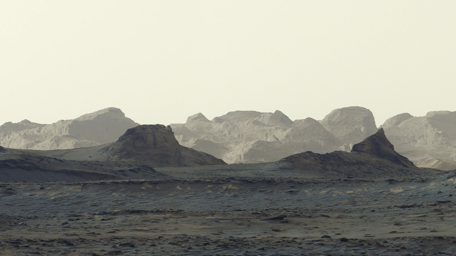
Curiosity captured morning light on distant Martian cliffs, pairing the cool tones of the foreground with the sunlit peaks of wind-carved formations known as yardangs.
NASA presented the panorama on October 6, 2026, describing it as the most detailed view yet of these particular distant formations. The images were taken on August 11, 2026, at 8:30 a.m. local Mars time, during sol 4,982 — the corresponding Martian day of the mission.
How the image was made
The full panorama was assembled on Earth from six Mastcam photographs. The image accompanying this article is Figure A, a crop of the wider panorama that concentrates on the distant cliffs.
The team omitted the usual white balancing to retain the scene’s early-morning appearance. In other published Mastcam images, this adjustment shows the landscape as it would appear under Earth lighting. Here, the cooler morning tones were retained. That does not make this an “unprocessed photograph,” however: the individual frames have already been stitched into a digital mosaic.
Mastcam is a two-camera system with 34 mm and 100 mm focal lengths, mounted approximately two metres above the ground. NASA lists an image size of about 1,600×1,200 pixels. Malin Space Science Systems built and operates the instrument. Combining multiple frames makes it possible to show a wider stretch of terrain than a single exposure can cover.
The cliffs Curiosity hopes to reach
Yardangs are rock formations sculpted by wind erosion. Wind removes loose material, while the sand it carries abrades the rock. They are not dunes made from accumulated sand: their shape results from material being worn away.
This particular layer extends for roughly 16 kilometres across the northwestern side of Mount Sharp, a mountain about five kilometres high. Curiosity has been climbing its slopes since 2014 and has now gained one kilometre in elevation, the greatest ascent achieved by a vehicle on Mars.
The layer stands out for its colour and unusual tilt compared with those the rover has already crossed. Its origin remains uncertain: one hypothesis is that it formed from deposits of volcanic ash. Older layers may have eroded before it was deposited, leaving a gap in Mount Sharp’s geological record.
The team hopes to reach the base of the yardangs sometime in 2027 and study them at close range using the robotic arm. First comes a drive through layers enriched in sulfates and carbonates, signs of ancient drying at the surface.
What we think
What holds our attention photographically is the way the landscape separates into layers. The dark foreground provides a reference for reading the brighter cliffs in the distance. Successive ridgelines gain a sense of separation, while the almost empty sky gives the terrain room to stand out. The composition works before we even know which planet we are looking at.
We find the clear account of the processing just as useful. With images from scientific missions, the caption needs to explain how the view is being presented: a single frame or a mosaic, a complete image or a crop, with or without a particular colour adjustment. Those details do not diminish the scene’s impact. They help us understand exactly what we are seeing and which decisions came between capture and publication. For a photographer, that transparency is more valuable than a vague assurance that an image is “unedited.”
Frequently asked questions
Where can I find the full panorama?
The official PIA25629 image page offers the full panorama as an 11.91 MB PNG and the separate Figure A crop as a 2.70 MB PNG. The image in this article is based on Figure A.
Can the image be republished for news reporting?
NASA and JPL guidelines allow informational and journalistic use under their terms, with source acknowledgement and without implying endorsement of a product or service. The credit for this image is NASA/JPL-Caltech/MSSS. Advertising uses and third-party material may be subject to additional restrictions.